Monday, July 25, 2011

Mt. Yale


Summary:

Date: July 24, 2011
Elevation: 14, 196' (Mt. Belford
Range: Sawatch Range
Location: 10 miles West of Buena Vista
Climbed With: Damon (friend)
Conditions: Mostly sunny, warm
Trailhead: Denny Creek
Route: Southwest Slopes (Class 2)
Round Trip: 9.5 miles
Elevation Gain: 4300'

Timeline: Trailhead: 6:50 AM
                Summit: 9:50 AM
                Start Descent: 10:20 AM
                Trailhead: 12:30 PM


So today I fell off the side of Mt. Yale. Details to follow.


The day started with a 4 AM when we set off from Denver. As is becoming customary, I stopped to get gas, coffee and a snack. The ride to the TH was dark and uneventful. Soundtrack: Aer + Atmosphere. We stopped once more to use the restroom in Buena Vista at All Goods Quick Stop. After making good time we were at the (busy) TH at 6:45. The road is paved to Denny Creek. I packed up, laced my New Balance boots, and we took off on the trail.


We reached the first stream crossing in 25 minutes and continued a steady pace, gaining elevation out through the valley. 


As many would agree, the new trail is excellent. Thank you CFI for taking names and kicking ass for the last 17 years. 


New Trail


While gaining the ridge on the great trail we stopped around 9:00 for a short 5 minute break and then pushed up towards the summit. Once on the ridge, the trail runs out, but the remaining route is well cairned and the summit is not far off. With some occasional hand placements and easy boulder-hopping we ascended the final pitch to the summit.


On the Ridge


Final Pitch


The wind was calm on top as it had been all day. Mostly sunny skies with great views of Princeton to the south and Harvard/Columbia to the north. On this note, I have never been good at identifying other peaks from the top of 14ers. I think this skill is called orientography? Anyway, I can't ID a peak to save my life. We summited at 9:50 and started to descend at 10:20 after lunch.


East


West


South


North
Numero one nine


For being a Sunday, I thought the traffic levels were not all that bad.


About a mile into the hike from the TH there are a bunch of 1" diameter holes in the rocks in and around the trail. We couldn't quite put a finger on what they were. We settled on alien landing spots (because if you think about the percentage of living organisms on earth being really small, one could argue that it would be more likely for ET to be smaller than us right? But we figured it wouldn't matter because they'd be like ants and be able to lift a million times their body weight and take us over anyway...). We continued down towards the trailhead. Made the stream crossings again and finally out of the woods and down the short slope into the parking lot. Overall it was a great hike with great weather, awesome columbines, and nice views. But wait didn't I fall off of Mt. Yale today? We see the parking lot, we are going down a managable slope into the TH, the car is right there. We made it right? Haha I would soon be rolling on the floor laughing (the "on the floor" being involuntary). 15 steps from the parking lot I ate it and slid down the slope into the parking lot. I sat there in the trail laughing and dusting off my hands and knees while pondering the irony of my "New Balance" shoes. What a capper to the day.


Friday, July 8, 2011

La Plata Peak

Hit the road around 5, stopped to get gas and coffee in Denver. Turned on 390, smooth sailing...Until 9.2 miles in there is unmarked drainage ditch that is hard to see. We smacked it pretty good. A short while after we were in Winfield. The TH is at West Winfield. We accidentally went up the road to South Winfield, looking for the described cemetery on our directions but looked closer at the map and realized our mistake. The detour took us on some fun 4WD though! We got back to the main intersection, and it is easy to mistake the right turn to West Winfield as a driveway to the cabin right there.

The 4WD to the TH wasn't incredibly rough but we were thankful for some good clearance. We parked in the meadow where the road splits and starts rising to the right. We finished packing, and were on the trail. 

At the TH


I have decided to break the hike down into 5 sections: 1) Below treeline/willows 2) Gaining the Ridge 3) On the Ridge 4) Summit! 5) Descent

1. Below Treeline and Through the Willows

In the trees, the trail follows a stream and we gradually gained elevation. There are several easy stream crossings and it isn't long before you are out of the forest. The trail is slightly rough, but in great shape for an alternate route. As the trees start to thin, the willows begin to appear, and we found ourselves in a muddy willow meadow.

Starting the Willows

 The first part of the willows took the most route-finding. As seen in this picture, the trail runs into a muddy plain but trail is straight across on the left. 


The mud can be deceiving and almost sucked my boot off when I was in half way up my calf. At this point we spread out a bright blue T-Shirt where we could see both ends of the trail from. At first it was difficult to navigate the elbow-high bush but we soon got the hang of it. With a close eye on the cloudy sky, we made our way through the mud. It was steady going and at the end of the meadow, we crossed one last stream and began the ascent to gain the ridge. 

2. Gaining the Ridge

This was one of the more mentally demanding parts of the route. This part was very steep and parts of the trail were blocked by snow. We avoided the snow by skirting the sides of it on the way up and completely bypassing it on the descent. The trail was well defined otherwise but contained plenty of gravel-like conditions and took some "mind over matter" mentality to reach the top. The clouds were still looming and blowing by fast above us and thus made the ascent up the ridge that more mentally gut-wrenching. Soon enough we were on the ridge and the clouds continued to be broken up to the north-west so we pushed on up the ridge.

3. On the Ridge

As good as route descriptions can be, they still can mislead slightly. Whatever the case may be, we half-concluded that a lot of our work was behind us and that that was the "crux" of the route. We were wrong. 


The false summit ahead of us was the most demanding section of the trip. The trail runs out into the boulder field and the cairns start to pop up. Again, for an alternate route, this section was well cairned and had good sections of tread. Gaining the first false summit took a good amount determination. Up and up we went, wanting to see the top, we did. Except that it was much farther down the ridge to go yet. We breaked here, checked the weather (the clouds still breaking up to the north-west of us and nothing too dark yet, but the still zipping past above us) and demolished some cliff bars that gave us second wind as we pushed for the top. Following the rest of the ridge was not difficult and required a bit of attention from cairn to cairn. There is one flat, short snow field that we had to negotiate and after the final false summit, La Plata was in view.


4. Summit

The peak was somewhat socked by clouds but still offered great views. We spent about 20 minutes on top of the windy peak and noshed down some fresh fruit. After a few pics and a phone call to mom we started down the ridge. 


5. Descent 

We were making good time back across the ridge and were now walking west, where we could keep a good eye on the weather. Over the false summits we went and across the bottom of the ridge. On the way down the loose gravel we spread ourselves out to prevent any accidental slides from becoming a bigger problem. Riding our concentration, we navigated down back to the stream crossing signaling the start of the willows. At this point we heard a low, soft rumble of thunder to the west, so we kept pace through the willows, comforted that treeline/the car were not far at all. My blue T-Shirt guided us in and pointed us out and we were down in the trees. Shortly after we stumbled out into the clearing where Roxanne was waiting for us, just showing off...


Overall, a great hike on a route that I would recommend. The weather was unsettling but was never an issue. It was a fun drive and a good length and made for a great way to spend a day in the Colorado summer.


Date: July 8, 2011
Route: Southwest Ridge
Elevation: 14, 336'
Range: Sawatch Range
Location: 15 miles Norhtwest of Buena Vista
Climbed With: David (brother), Tim (brother)
Conditions: Mostly cloudy, cool, gusty at times
Trailhead: West WinfieldRoute: Southwest Ridge (Class 2)
Round Trip: 7 miles
Elevation Gain: 3380'
Timeline: Denver: 5:00AM
              Trailhead: 7:50AM
              
              Log at end of Willows: 9:00AM
              Top of Ridge: 9:30AM
              
              Summit: 10:53AM
              Off Summit: 11:10AM
              Top of Ridge: 12:30PM
              Log at end of Willows: 1:00PM
              Trailhead: 1:50PM
Notes: 

Pictures: 


Summit Shot


Wednesday, June 29, 2011

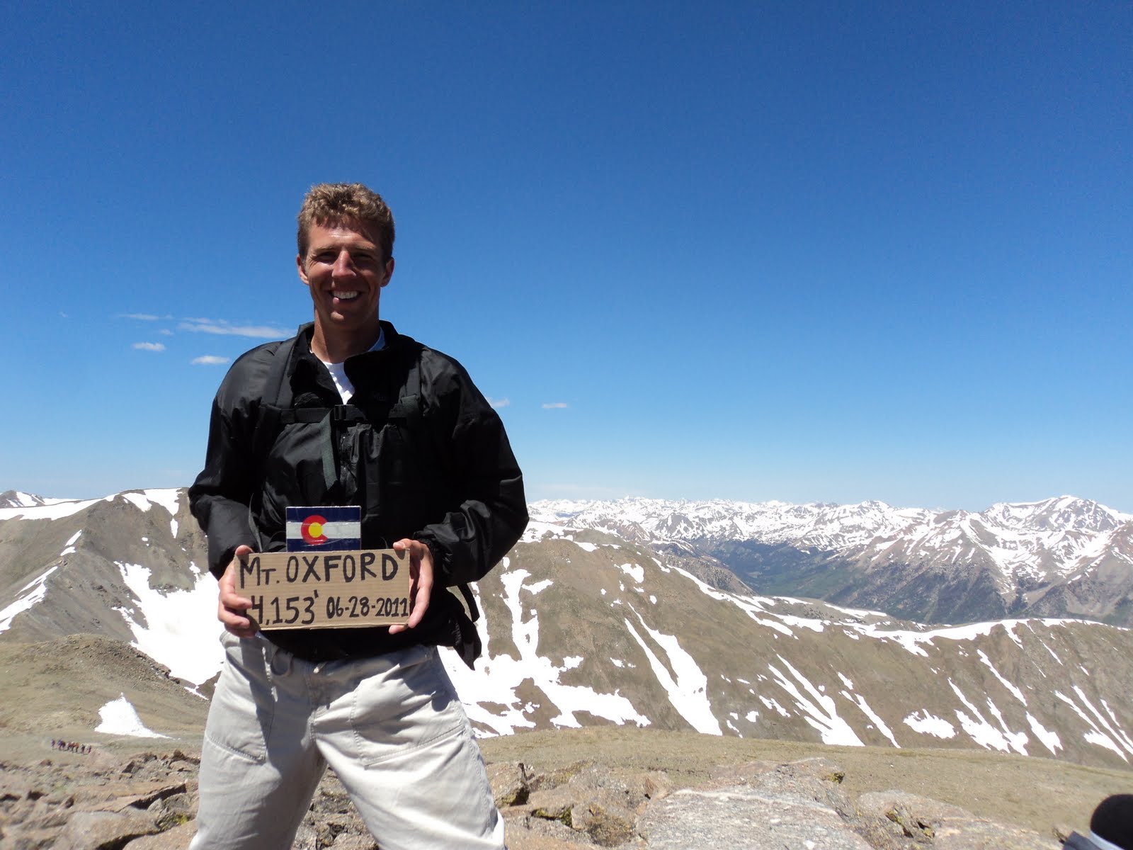
Mt. Belford & Mt. Oxford


After another long night of work, I printed off more NatGeo maps and tied up the loose ends of the pack. David got Cliff Bars and fresh fruit from King Soopers earlier so we would be ready to hit the road when 4 AM came the next morning. We set off in the trusty CR-V for Missouri Gulch, via I-70 and CO-91. We hauled stopping only at the "Kum-and-Go" in Idaho Springs for Pretzels and Coffee, and then once again when I missed the exit for Leadville at Copper Mountain, which was a mistake because you can't turn around until that rest-stop 5 or 10 miles past Copper, adding 15 or so minutes onto the trip...ahh I'm an idiot. Soundtrack: well the soundtrack for the trip was mixed, but mostly KBCO on Iheartradio. 

The road to the TH was clear, dry and easy 2WD and no issue whatsoever. We arrived at the trailhead around 6:40AM and proceeded to use the facilities and strap on the packs. Hit the trail right at 6:45. We were extremely discouraged at how the route immediately starts by descending to the bridge, because after all, every step down is one more you have to eventually go back up. Ha. Only a poetic reflection on the day ahead. 

Below treeline was uneventful until a series of stream crossings in the vicinity of 11,000'. Those were fun and easy with a little concentration. Shortly after we reached the old shack that was populated with tents, and shortly after that we found ourselves at the trail junction looking back down into the beautiful valley.


And so the incline begins. We tackled the ridge head on and kept a good pace through the switchbacks. We passed the CFI group working on the ridge, thankful for their work! With intermittent stops and breaks we finally reached the flat area towards the top and with the summit just a ways to go, we trucked on in. The summit was well attended and we ran into some pretty fun people, most of which participated in the traverse to Oxford.  


Descending the ridge took a touch of concentration, all the while trying to push out of your mind the fact that you'll be headed back up this ridge on the 8th mile of the day. 


David exercising mountaineering rule #1: never pee uphill...


But anyway, we hiked up the gentle Oxford slope towards what we called "The Butt" (see pic below) and were on top of Oxford under an hour.


We stayed long enough to polish off the fruit and some sandwiches and then began the low-anticipated hike to Belford. It was one of those things where it wasn't a hard ascent by any means, but after the 8th or so mile of the day, you just would rather be going down-hill. We finally were back on top of Belford, and stopping just briefly to soak up the views of an awesome basin we were finally headed down. 


Nothing special headed down, except when I got sloppy and lazily postholed into the little bit of snow on the trail and bottomed into a puddle of ankle-high mud. Fun. But the weather was too great to get down about that and kept going down to the car. We pondered many of life's great questions, most important of which was what sound do marmots make? We were stumped and decided that they don't make noises, but if they did it would be a Pokemon-like "marmot! marmot!" noise. We ended up solving world hunger and global warming by the time we reached the TH. 

All in all a great hike, great weather and some Colorado fun! Back down in Morrison for some Willy's Wings for dinner by 6. 

Date: June 28, 2011
Elevation: 14, 197'
Range: Sawatch Range
Location: 20 miles Southwest of Leadville
Climbed With: David (Brother) and Damon (Friend)
Conditions: Sunny, windy, afternoon clouds, no precipitation 
Trailhead: Missouri Gulch
Route: Northwest Ridge (Class 2)
Round Trip: 11.0 miles
Elevation Gain: 5800'

Timeline: Denver: 4:00AM
                Trailhead: 6:45AM

                Summit (Belford): 10:00AM

                Summit (Oxford): 11:30 AM
                Trailhead: 3:00 PM                

Pictures:


Monday, June 13, 2011

Mt. Shavano

Welcome from 14ers.com! I haven't blogged before and I rarely do trip reports. Let me know what you think... Just a little journal action first, but there are just some stats and pics toward the bottom if that's what you're looking for. Hope its okay let me know how to improve!

As this is my first blog, a little about me. My name is Dan. I am 19, from Littleton, CO and a chemistry major Gonzaga University. This was my 15th 14er. Here it goes...

After getting off work late last night (11:30PM) (smh restaurants), I came home threw my pack together (I was impressed that I did not forget anything major, but could have used some chapstick...) and hit the hay. Oh and by the way, I bought a 3" knife that I luckily didn't have to use, and a sweet $11 compass from REI on Monday. I bring this up because the compass included 5 free NatGeo TopoMaps which are pretty awesome and I would recommend. But so I got all my gear and we left Denver right around 5. After quite an uneventful drive (soundtrack: O.A.R. (live)), we arrived at the TH at 7:45 and headed out soon after. We just so happened to find the Pearl-White Subaru pow-wow.


Being away from the Colorado outdoors for apprx. 8 months, it was really good to be welcomed back by this view right off the TH.


Not much going on below tree-line...it was a steady incline with some stream-crossings. Until right around tree-line there is no snow to contend with, but nothing too major and there is good foot pack through. Then we came across the slopes above tree-line to the saddle. It was really windy and all members of the party weren't quite in the best shape. 

And then it got a bit weird...Tim and Shannon told me to go for the summit while they stayed at the saddle. Normally, I don't think separating is ever a good idea. However, given the circumstances (decent weather, heavy traffic on the peaks, and visibility from the saddle to high up the summit), I decided to go for it. 


There was also cell phone reception at the summit and I called the others from the top. 

And then I screwed up. I saw Tabby so tantalizingly close and moseyed my way across the ridge toward it. I saw hikers on the summit and kept an eye on them. I ended up at the saddle between Shavano and Tabby, but with everyone coming off of Tabby, I had to turn myself around. 

Tough pill to swallow, Tabby straight ahead


It was the right decision, but should have been made much, much earlier. It took a taxing amount of calories to regain Shavano, not to mention the time it took while the others remained on the cold, windy saddle. Coming off the peak back and heading back toward the group I was tired (mentally/physically) and I somehow mistook the saddle between Shavano and the peak directly west of Shavano for the saddle between Shavano and Esprit Point. It was not a big deal and I realized my mistake fairly early (embarrassing nonetheless, sheesh!) but just took even more time rejoining the rest of the group.

Anyway, from there the descent until the snow/trees was very windy and whatnot, but once back in the woods not much else to report. Some really nice views in the late afternoon approaching the TH. And finally after a long day, back to the car. Killer tan lines (forgot sunscreen on my legs) and Sanuks (God's gift to mankind). (Too much parenthetical. Will cut down next time.)


Thanks for reading!

Side notes: 

Saw an opportunity for camping here at this spot, maybe for a redemption trip! 


And also, saw this tree on the way out. Our best guesses were either some sort of ropes or bindings? Or infection. We were leaning toward infection. Maybe someone knows?


Misc. Pics.

From the Summit

From the Summit

From the Summit

From the Summit


Date: June 12, 2011
Elevation: 14, 229'
Range: Sawatch Range
Location: 15 miles Northwest of Salida
Climbed With: Tim (Brother) Shannon (Sister-in-Law) Maggie (Tim&Shannon's dog)
Conditions: Sunny, windy, afternoon clouds, no precipitation 
Trailhead: Blank Gulch
Route: East Slopes (Class 2)
Round Trip: 9.25 miles
Elevation Gain: 4600'

Timeline: Denver: 5:00AM
                Trailhead: 7:45AM
                Summit: 1:20PM
                Trailhead: 5:00PM(ish)

Pictures:

Summit Shot

Tuesday, August 10, 2010

Huron Peak

Date: August 10, 2010
Elevation: 14, 003'
Range: Sawatch Range
Location: 16 miles Northwest of Buena Vista
Climbed With:N/A
Conditions: Sunny, breezy
Trailhead: Clear Creek/S. Winfield
Route: North Ridge (Class 2)
Round Trip: 11 miles
Elevation Gain: 3800'

Timeline: Denver: N/A
                Trailhead: N/A
                Summit: N/A
                Trailhead: N/A

Notes:

Pictures:

Summit Shot

Saturday, August 7, 2010

Mt. Beirstadt

Date: August 7, 2010
Elevation: 14, 060'
Range: Front Range
Location: 35 miles West of Denver
Climbed With: David (brother)
Conditions: Mostly sunny, warm
Trailhead: Guanella Pass
Route: West Slopes (Class 2)
Round Trip: 7 miles
Elevation Gain: 2850'

Timeline: Denver: N/A
                Trailhead: N/A
                Summit: N/A
                Trailhead: N/A

Notes:

Pictures:

Summit Shot

Monday, August 2, 2010

Mt. Sherman

Date: August 2, 2010
Elevation: 14, 036'
Range: Mosquito Range
Location: 10 miles West of Fairplay
Climbed With: Tim (older brother) and David (younger brother) and Tim's dog Maggie.
Conditions: Mostly cloudy, cool
Trailhead: Fourmile Creek
Route: Southwest Ridge (Class 2)
Round Trip: 5.25 miles
Elevation Gain: 2100'

Timeline: Denver: N/A
                Trailhead: N/A
                Summit: N/A
                Trailhead: N/A

Notes:

Pictures:

Summit Shot